, formerly the NOAA National Geophysical Data Center (NGDC)")
|

|
Core Data from the Deep Sea Drilling Project
DSDP holes in the Black Sea
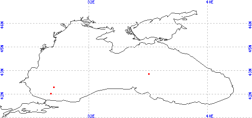
Red dots represent sites. Overprinted locations include links to adjacent sites.
hole leg latitude longitude 381 42 41.6708 29.4160 380 42 42.0990 29.6137 380A 42 42.0990 29.6137 379 42 43.0050 36.0117 379A 42 43.0050 36.0117 379B 42 43.0050 36.0117 |
|
Cite as: Deep Sea Drilling Project (1989): Archive of Core and Site/Hole Data and Photographs from the Deep Sea Drilling Project (DSDP). National Geophysical Data Center, NOAA. doi:10.7289/V54M92G2 [access date]
Please see NOAA's privacy and disclaimer information. Send questions or comments to mgg.info@noaa.gov.
|