, formerly the NOAA National Geophysical Data Center (NGDC)")
|

|
Core Data from the Deep Sea Drilling Project
DSDP holes in the Coral Sea
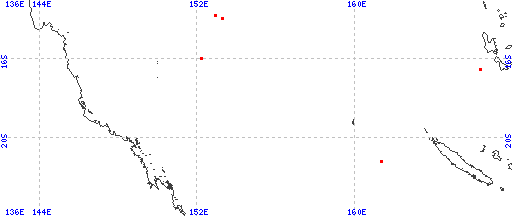
Red dots represent sites. Overprinted locations include links to adjacent sites.
hole leg latitude longitude 587 90 -21.1847 161.3332 209 21 -15.9365 152.1878 209A 21 -15.9365 152.1878 287 30 -13.9112 153.2655 210 21 -13.7665 152.8963 |
|
Cite as: Deep Sea Drilling Project (1989): Archive of Core and Site/Hole Data and Photographs from the Deep Sea Drilling Project (DSDP). National Geophysical Data Center, NOAA. doi:10.7289/V54M92G2 [access date]
Please see NOAA's privacy and disclaimer information. Send questions or comments to mgg.info@noaa.gov.
|