, formerly the NOAA National Geophysical Data Center (NGDC)")
|

|
Core Data from the Deep Sea Drilling Project
DSDP holes in the Gulf of California
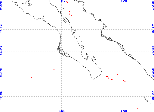
Red dots represent sites. Overprinted locations include links to adjacent sites.
hole leg latitude longitude 473 63 20.9653 -107.0635 485A 65 22.7487 -107.9038 485 65 22.7492 -107.9035 482D 65 22.7885 -107.9918 482C 65 22.7890 -107.9928 482F 65 22.7893 -107.9935 482E 65 22.7895 -107.9927 482 65 22.7897 -107.9938 482A 65 22.7897 -107.9933 482B 65 22.7897 -107.9933 483C 65 22.8830 -108.7430 483A 65 22.8832 -108.7473 483B 65 22.8832 -108.7473 483 65 22.8833 -108.7483 474A 64 22.9593 -108.9780 474 64 22.9620 -108.9807 476 64 23.0405 -109.0892 475 64 23.0505 -109.0532 475B 64 23.0560 -109.0595 475A 64 23.0573 -109.0638 484A 65 23.1858 -108.3937 484 65 23.1887 -108.3933 477B 64 27.0293 -111.3992 477A 64 27.0300 -111.3988 477 64 27.0308 -111.4003 478 64 27.0968 -111.5075 481 64 27.2530 -111.5077 481A 64 27.2530 -111.5077 479 64 27.8460 -111.6248 480 64 27.9017 -111.6557 |
|
Cite as: Deep Sea Drilling Project (1989): Archive of Core and Site/Hole Data and Photographs from the Deep Sea Drilling Project (DSDP). National Geophysical Data Center, NOAA. doi:10.7289/V54M92G2 [access date]
Please see NOAA's privacy and disclaimer information. Send questions or comments to mgg.info@noaa.gov.
|