, formerly the NOAA National Geophysical Data Center (NGDC)")
|

|
Core Data from the Deep Sea Drilling Project
DSDP holes in the Gulf of Mexico
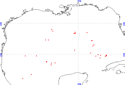
Red dots represent sites. Overprinted locations include links to adjacent sites.
hole leg latitude longitude 89 10 20.8902 -95.1122 88 10 21.3822 -94.0035 93 10 22.6208 -91.4797 85 10 22.8415 -91.4228 85A 10 22.8415 -91.4228 86 10 22.8747 -90.9625 87 10 23.0150 -92.0860 3 1 23.0300 -92.0433 2 1 23.4550 -92.5867 536 77 23.4898 -85.2097 535 77 23.7080 -84.5162 96 10 23.7427 -85.7633 91 10 23.7733 -93.3462 539A 77 23.7867 -84.4198 539 77 23.7890 -84.4198 90 10 23.7967 -94.7682 540 77 23.8288 -84.3708 538A 77 23.8492 -85.1655 538 77 23.8497 -85.1710 97 10 23.8842 -84.4457 537 77 23.9335 -85.4603 95 10 24.1500 -86.3975 94 10 24.5273 -88.4693 614 96 25.0680 -86.1368 614A 96 25.0680 -86.1368 615 96 25.2223 -85.9922 615A 96 25.2225 -85.9925 624 96 25.7540 -86.2772 624A 96 25.7540 -86.2772 623 96 25.7682 -86.2307 92 10 25.8448 -91.8215 1 1 25.8583 -92.1833 622 96 26.6902 -88.3803 622A 96 26.6902 -88.3803 617 96 26.6988 -88.5278 617A 96 26.6988 -88.5278 621 96 26.7310 -88.4960 616A 96 26.8108 -86.8810 616B 96 26.8110 -86.8808 616 96 26.8112 -86.8805 620 96 26.8353 -88.3708 618 96 27.0113 -91.2622 618A 96 27.0113 -91.2622 619 96 27.1935 -91.4090 619A 96 27.1935 -91.4090 |
|
Cite as: Deep Sea Drilling Project (1989): Archive of Core and Site/Hole Data and Photographs from the Deep Sea Drilling Project (DSDP). National Geophysical Data Center, NOAA. doi:10.7289/V54M92G2 [access date]
Please see NOAA's privacy and disclaimer information. Send questions or comments to mgg.info@noaa.gov.
|