, formerly the NOAA National Geophysical Data Center (NGDC)")
|

|
Core Data from the Deep Sea Drilling Project
DSDP holes in the Indian Ocean
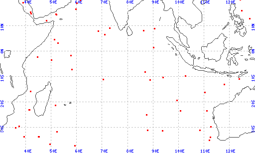
Red dots represent sites. Overprinted locations include links to adjacent sites.
hole leg latitude longitude 252 26 -37.0407 59.2388 251 26 -36.5042 49.4858 251A 26 -36.5042 49.4858 264 28 -34.9688 112.0447 264A 28 -34.9688 112.0447 258 26 -33.7948 112.4737 258A 26 -33.7948 112.4737 258B 26 -33.7948 112.4737 247 25 -33.6255 45.0113 246 25 -33.6202 45.1595 250 26 -33.4623 39.3692 250A 26 -33.4623 39.3692 245 25 -31.5337 52.3018 245A 25 -31.5337 52.3018 255 26 -31.1312 93.7287 257 26 -30.9860 108.3498 254 26 -30.9692 87.8953 249 25 -29.9498 36.0770 259 27 -29.6175 112.6963 248 25 -29.5297 37.4747 253 26 -24.8775 87.3662 256 26 -23.4558 100.7743 263 27 -23.3238 110.9635 244 25 -22.9312 41.4330 243 25 -22.9082 41.3998 239 25 -21.2945 51.6788 212 22 -19.1890 99.2973 260 27 -16.1445 110.2987 242 25 -15.8442 41.8205 261 27 -12.9472 117.8927 238 24 -11.1535 70.5260 214 22 -11.3368 88.7180 262 27 -10.8698 123.8463 213 22 -10.2118 93.8962 213A 22 -10.2118 93.8962 211 22 -9.7755 102.6992 215 22 -8.1217 86.7917 237 24 -7.0832 58.1247 240 25 -3.4873 50.0537 240A 25 -3.4873 50.0537 241 25 -2.3707 44.6795 236 24 -1.6770 57.6475 216 22 1.4622 90.2080 216A 22 1.4622 90.2080 235 24 3.2343 52.6940 234 24 4.4827 51.2247 234A 24 4.4827 51.2247 218 22 8.0070 86.2828 217 22 8.9262 90.5388 217A 22 8.9262 90.5388 |
|
Cite as: Deep Sea Drilling Project (1989): Archive of Core and Site/Hole Data and Photographs from the Deep Sea Drilling Project (DSDP). National Geophysical Data Center, NOAA. doi:10.7289/V54M92G2 [access date]
Please see NOAA's privacy and disclaimer information. Send questions or comments to mgg.info@noaa.gov.
|