Versions Available
- 10 sheet set
(each 74 x 90 cm)
1:1,000,000 scale
at 38 deg. N
- Photo-reduction to
1:5,000,000 scale
- downloadable images
|

click on map above for a larger preview
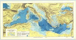
This bathymetric chart is published by the Charts Division of the Head Department of Navigation and Oceanography in Russia under the authority of the Intergovernmental Oceanographic Commission (IOC) of UNESCO. Originally compiled from ninety 1:250,000 scale British Admiralty Mercator plotting sheets for oceanic soundings, it presents the bathymetry and land topography as 200 m contours with supplemental 20 m, 50 m, and 100 m contours at sea. Several versions are available;
a 10 sheet set (each 74 X 90 cm) at 1:1,000,000 scale at 38 degrees N, and a photo-reduction to 1:5,000,000 scale. This chart, with an inset of the entire Black Sea at half scale, is also the basemap for a Geological/Geophysical series with Bouguer gravity anomalies (IBCM-G), seismicity (IBCM-S), thickness of Plio-Quaternary sediments (IBCM-PQ), unconsolidated bottom surface sediments (IBCM-SED), and magnetic anomalies (IBCM-M). Digital variants and explanatory brochures for these series are in preparation. The digitized marine contours are available on CD-ROM as part of the British Oceanographic Data Centre's GEBCO Digital Atlas.
|